[5.4.22] 39-Min Read: Having found myself immersed in first the history of Kennesaw Mountain National Park, and then the development of Marietta vis-a-vis my discovery of the Sanborn Map Company’s Insurance Maps of the City of Marietta from 1885 – 1923, I found myself compelled to go further down the Rabbit Hole into more about the history of Marietta, Cobb County and the state of Georgia, noting their respective early histories are very-much intertwined.
Table of Contents: Click on Links to Jump to Section
- Introduction
- Early Human Life in Cobb County, 10,000BC – 1540
- European Exploration Period, 1540 – 1732
- Georgia Becomes Great Britain’s 13th American Colony, 1732 – 1749
- Georgia During the Revolution & Acquisition of Native American Land, 1770’s
- Dispersed Farmsteads (1780 AD – 1838 AD)
- Post-Revolutionary Georgia Prospers and Expands, 1785 – 1829
- Cherokee Indian Removal Period: 1832 – 1838
- Cobb County & Marietta are Established, 1824
- The Civil War Years, 1860 – 1665
- Post-Civil War and Reconstruction, 1665 – 1892
- Cobb County Courthouse History, 1873 – 1995
- The 20th Century Arrives, 1905 – 2010
- Supplement: Europeans & Smallpox: Unintended Consequences…
Introduction:

At right is a Google Earth, composite satellite view of central Marietta, Georgia, within the west-end of the GA-120 Loop. Having lived in Cobb County for 30 years and discovered local history-buff Facebook pages I thought I had a good sense of the history. However, over the past few months I’d realized I knew very little about the “real” history”.. history that matters.
What follows is a series of short facts, news items and trivial item of information and, where warranted, some longer narratives that walk-through the history of the city Marietta, Cobb County and Georgia and how the region of land in the southeast American Continent came to be, at least per the history books.
I believe a reading of the novel “1491 – New Revealation of the Americas Before Columbus” should be required reading since it answers so many questions about why when the Europeans landed on what were, in reality, well-developed continents — North and South America — that had active land and wildlife management programs in place created by the indigenous people over 20,000 years. It’s estimated that as many as more than 18-million people were living on these two continents just before the arrival of Hernán Cortés in 1517 and Hernando De Soto in 1539, who introduced non-native diseases that wiped-out between 90% and 95% of the indigenous people.
So, with that as an introduction, here is my summary of how what we now recognize as the state of Georgia in the United States of America, Cobb County and it’s seat of government and largest city, Marietta, came to be. The material presented here is, in most cases, not original and things I’d found on various websites established to share Georgia, Cobb County and Marietta history, as well as subject-specific websites. Were this a commercial website I use to generate revenue, I would have definitely included numbered end notes for all of the entries to give credit where credit is due, but since this is just a hobby the fair use provisions of copyright are applied.
Legend to Color Coded Text: I’ve applied different colors to the text used below as follows, remembering that linked text is presented in Red.

That said, most of what immediately follows as well as the subsequent sections on the Dispersed Farmland & Cherokee Indian Removal as shown in an orange text mostly comes from Access Genealogy.com’s Native American History of Cobb County:
Early Human Life in Cobb County
Earliest Times (10,000 BC)
Archaeologists believe humans lived in Cobb County for at least 12,000 years, perhaps much longer. Herds of giant mammals roamed the river bottom lands and mastodons, saber tooth tigers, giant sloths and other massive mammals died out over 8,000 years ago, when indigenous Clovis Culture hunters inhabited the American continents.
What is now Cobb County was an ideal location for bands of hunters and gatherers. The county’s network of creeks and wetlands provided a diverse ecological environment for game animals and edible plants. Indigenous people, as they did throughout North America, set massive brush fires several times a year that cleared the landscape of shrubs and created natural pastures for deer and elk. The landscape that European settlers encountered when they arrived in colonial America and the local Piedmont thousands of years later was not natural: it had been altered for thousands of years by Indigenous people to create optimum environments for the natural production of food sources.
Woodland Period (1000 BC – 900 AD)
The Etowah, Chattahoochee and Flint River Valleys were locations of some of the earliest permanent villages in North America. The early villages were relatively small and dispersed. but there was socialization among these villages for the need to find spouses that were not closely related.
The Woodland Period peoples of the region built numerous mounds. Apparently, most mounds were primarily for burials, but may have also supported simple structures that were used for rituals or meetings. The mounds grew in size over the generations by piling soil and detritus from the village over recent burials. The occupants of the region around Cobb County prior to around 200 BC were likely Southern Siouans until they were likely displaced out of the major river valleys by Muskogeans.
Archaeological evidence in the Chattahoochee and Flint River Valleys suggests that the first Muskogean farmers entered northeast Georgia around 400 BC, after migrating from west-central Mexico. However, the region was probably was already occupied by ancestors of the Yuchi and Southern Siouans with languages similar to the Catawba. There may have been other ethnic groups whose identities have been concealed by time. Agricultural technology, cultural traditions and DNA probably blended between these peoples. Modern “Creek” Indians may represent a genetic mix of several indigenous ethnic groups.
Muskogean Town Dwellers (900 AD – 1784 AD)
Muskogeans brought advanced cultural traditions from Mexico and the Lower Mississippi Valley and formed provinces that were governed by large towns. Prior to arrival of Europeans, there were no Indian “tribes.” The large towns were usually located in the bottomlands on major rivers such as the Chattahoochee. Native Americans continued to live in what is now Cobb County, but their populations were concentrated along major creeks that flowed into the Etowah River.
One of the earliest “advanced” indigenous towns in the United States was founded on the Etowah River in Bartow County around 990 AD. Its founders were newcomers, who carried with them many Mesoamerican cultural traits. They may have been either Itza Mayas or the hybrid descendants of both Mayas and indigenous peoples. The language that most of the Creek Indians’ ancestors spoke in Georgia was Itsate (Hitchiti in English.) The Itza Maya’s also called themselves, Itsati. There are many Maya and Totonac words in the various dialects spoken by the Creek Indians that came from Mexico. Throughout the Southeast, many provinces began to share common artistic symbols and agricultural lifestyles.
One of the challenges this presents to archeologists, linguistics and historians is determining the origin of words used by indigenous people to name things. As an example, some scholars note that “Kennesaw” is derived from the Cherokee word “Gah-nee-sah” meaning cemetery or burial ground. However, the Creek occupied the land in Cobb County before the Cherokee and using Itsati dialects, “Kennesaw” (kanos-sawa), literally translates to “skunk-raccoon” and is an old name for the Hognose Skunk. The Hognose Skunk is the largest of all skunks and was indigenous to the Southern Appalachians.
As noted in Access Geneology’s Native American History of Chattahoochee County The popular explanation of the meaning of Chattahoochee is that it is Creek word meaning, “River with the shining rocks.” This is probably not accurate. Until the late 1700s, there was a large Creek town with several mounds, where Six Flags Over Georgia is now located. In the Itsate (Hitchiti-Creek) language, it was named Cata-hvci (pronounced Chata-hawchee,) which literally means “Red River” in Itsate-Creek. The river at this town site is often clay red and contains no visible stones. When most of the Creeks were forcibly deported to the Indian Territory (Oklahoma,) they called a principal river through their lands, the Red River.

Smallpox is Introduced / 1492 – 1620: A sidebar / supplemental discussion on Smallpox and how it decimated the indigenous people of the Caribbean, and both North and South America follows this article. Smallpox did not exist on the American Continent before Europeans arrived. Smallpox and other European diseases killed so many indigenous Americans that entire civilizations disappeared.

Georgia’s History / March-May 1540 – Spanish explorer Hernando De Soto reaches southern Georgia, finding Creek Indians and further north, the Cherokee Indians, who numbered about 25,000 inhabited the area from the Ohio River to the north to the Chattahoochee in present day Georgia, and from the valley of the Tennessee east across the Great Smoky Mountains to the Piedmont of the Carolinas.
European Exploration Period (1540 AD – 1717 AD)

There is evidence that European diseases began affecting coastal populations as early as 1500 AD when indigenous American traders carried the microbes northward from Cuba and then into the lowlands near the Atlantic Ocean and Gulf Coast. Shortly after the Hernando De Soto Expedition passed through Georgia in 1540, waves of European diseases began to decimate the indigenous American population. De Soto probably passed through or near Macon, GA in March of 1540. The indigenous people of the future Cobb County would have been exposed to deadly pathogens at least by the summer of 1540. Anthropologists currently believe that the indigenous population of Georgia dropped about 95% between 1500 and 1700 AD.
The Kingdom of Spain claimed all of the Chattahoochee and Flint River Basins, including the future Cobb County, from 1567 until 1745. This claim was based on the Juan Pardo Expedition and a surveying expedition authorized by Governor Don Benito Ruiz de Salazar Vallecilla of the Province of La Florida around 1647. The surveying and gold prospecting expedition followed the Chattahoochee River to its source at Unicoi Gap. The Governor then established a trading post in the vicinity of the Chattahoochee headwaters. The Spanish explorers and traders definitely passed through the future Campbell County on many occasions.
Agricultural Advancements (1500 AD – 1700 AD)
Almost immediately after Spanish missions were established on the coast of what became Georgia in the late 1500s, the ancestors of the Creeks were growing European fruits and vegetables in addition to their traditional crops. A Spanish expedition in 1600 observed peaches, pears and melons being grown in a village on the Ocmulgee River. By the 1700s, Creeks were also raising European livestock. Chickens and hogs were the first European animals acquired to supplement their turkey flocks and Mexican meat dogs. By the late 1700s, most Creeks owned horses and had become skilled herders of cattle, horses and hogs.
Creek Confederacy (1600 AD – 1800 AD)
The Creek Confederacy of “People of One Fire” was a political alliance formed by the remnants of many advanced indigenous provinces in the Lower Southeast. This alliance probable developed during the late 1600s. The member towns represented several ethnic groups, but the Muskogees and Itsati’s (Hitchitis) dominated the alliance. Muskogee was selected as the parliamentary language of the alliance. When British settlers first settled the coast of what is now Georgia, Itsati was spoken by most Creeks. By 1800, a composite Muskogee language had become the spoken tongue of Creek citizens.
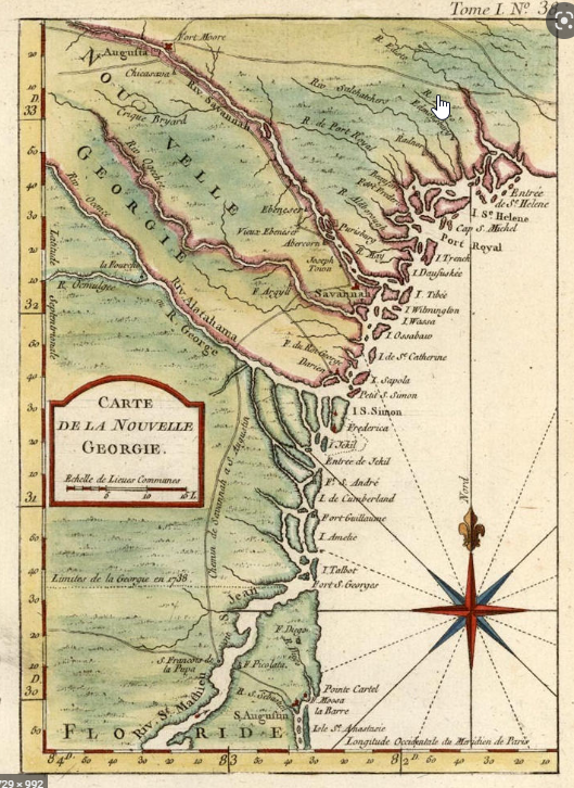
Georgia Becomes Great Britain’s 13th American Colony

Georgia’s History / 9 June 1732 – The Royal charter for Georgia was granted to Gen. James Oglethorpe, born in England on 22 Dec 1696
Georgia’s History / 12 Feb 1733 – After years of planning and two months crossing the Atlantic, James Oglethorpe and 114 British colonists founded the colony of Georgia. The original Georgia trustees prohibited slavery and large landholdings; Georgians would work for themselves on small farms. The 13th and last of the British colonies on mainland North America.
Georgia’s History / 7 July 1742 – A Spanish force invading Georgia from Florida were stopped by the colony’s British defenders at Bloody Marsh on St. Simons Island off the coast of Georgia, preserving the sovereignty of the colony.
Georgia’s History / 26 October 1749 – Following Oglethorpe’s return to England in 1743, remembering it was Oglethorpe who was opposed to slavery, the Georgia Colony revised its charter and ruled slavery to be legal. 10 February 1763 Britain gained control of Florida in 1763 through the first Treaty of Paris in 1763. After 20 years of British rule, however, Florida was returned to Spain as part of the second Treaty of Paris, which ended the American Revolution in 1783.
Georgia During the Revolution & Acquisition of Native American Land
Georgia’s History / Early 1770’s –Revolutionary fervor was slow to take hold in colonial Georgia, largely due to the effective leadership of Royal Governor Sir James Wright, had prospered under royal rule, and many Georgians thought that they needed the protection of British troops against a possible Indian attack. Sir James Wright was the third and last British Royal Governor who successfully encouraged the colony’s growth by attracting new settlers, productive negotiating with the Native Americans and overseeing the expansion of Georgia’s territory. Wright himself became one of the largest landowners in the state with eleven plantations and 523 slaves.
Georgia’s History / January 1776 – As revolutionary fervor spread through the colonies, Wright’s popularity, along with his administrative ability, effectively delayed rebellious activity in Georgia. However, in January 1776, a group of patriots led by Joseph Habersham issued an arrest warrant for Governor Wright and briefly took him prisoner. Within a month, Wright broke his parole and fled Savannah for London on the British Navy man-of-war, the HMS Scarborough.
Georgia’s History / The Declaration of Independence – Georgia did not send representatives to the First Continental Congress that met in Philadelphia, Pennsylvania, in 1774, nor did any of its elected officials go the Second Continental Congress in 1775, only Lyman Hall — an active and early leader in the Georgia’s evolutionary movement — representing St. John’s Parish was present as a non-voting participant. A year later, as an official representative of Georgia, Hall signed the Declaration of Independence along with Button Gwinnett and George Walton of Georgia.
Georgia’s History / 29 December 1778 – During the American Revolution, and having made little progress in their northern campaign, British troop began a southern campaign in an effort to defeat the colonials in America, capturing Savannah, then the capital of Georgia.
Georgia’s History / October 1779 – In the battle for Savannah in October 1779, Brigadier-General Casimir Pulaski was given charge of the armies of both the American and French forces under General Benjamin Lincoln and Count d’Estaing, respectively. The British had controlled Savannah for almost a year, and the combined French and American forces made a valiant attempt to gain control of the city but failed. While leading a cavalry charge, Pulaski was wounded and ultimately died without every gaining consciousness and became the only high-ranking officer of foreign birth to lose his life for the American cause during the American Revolutionary War.
Georgia’s History /December 1778 – When the British captured Savannah in December 1778 Sir James Wright was reinstated as Royal Governor.
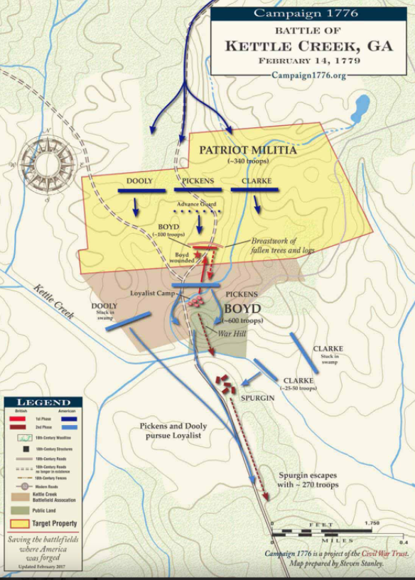
Georgia’s History / 14 February 1779 – The Battle of Kettle Creek fought on February 14, 1779, northwest of Augusta, the most important battle of the American Revolutionary War to be fought in Georgia. The victory by the American Patriot Militia virtually ended the movement to remain loyal to the England among Georgians. A Patriot loss at Kettle Creek would have forced the surrender of Washington’s forces in the north had given the British control of Georgia’s backcountry towns and settlements.
Georgia’s History / 14 July 1779 – Governor Sir James Wright returned to Georgia on July 14, 1779, and announced the restoration of Georgia to the crown, with the privilege of exemption from taxation. Thus, Georgia became the first, and ultimately the only one, of the thirteen states in rebellion to be restored to royal allegiance. The British continued to hold the city until after the battle of Yorktown in October 1781. Wright and the royal government evacuated Savannah on July 11, 1782 and returned to England.
Dispersed Farmsteads (1780 AD – 1838 AD)

After the American Revolution, Creek families dispersed across the vast territory now controlled by the Creek Confederacy. There were relatively few in the North Georgia Mountains, which were controlled by the Upper Creeks. Thousands of Cherokee refugees moved into northwestern Georgia during the 1780s and 1790s. The Creeks continued to occupy the east side of the Chattahoochee River northward to Habersham County.
In 1793, the Creek Nation was shocked to learn the U.S. Federal government had given away some of its most sacred territory, the Etowah River Valley down to the middle of what is now Paulding and Cobb Counties to the Cherokees. The remainder of northwest Georgia was taken from the Upper Creeks as punishment for assisting the British in the Revolution. Of course, the Chickamauga Cherokees had killed over a thousand settlers between 1776 and 1793, but Tennesseans were mad at the Upper Creeks for almost capturing Nashville. It was explained to the Creeks that the land theft was a “clerical mistake,” but they were promised that their other Sacred Lands, the Ocmulgee Bottoms, would be theirs forever.
From 1793 to 1838, the northern half of what was to become Cobb County was officially part of the Cherokee Nation, but had very few Native Americans living there. While the nearby Etowah River Valley had broad, fertile bottomlands for agriculture, suitable tracts for Cherokee farming methods near the Chattahoochee River were relatively small and dispersed. Most of the Cherokee and Creek inhabitants of the future Cobb County were apparently mixed bloods or families with Caucasian males as head of the household.
In 1718 the Creek Confederacy ceded a corridor along the east side of the Chattahoochee up to Clarkesville, GA. In 1821, it ceded a much larger tract of land that included present day Fulton and Dekalb Counties, plus the southern half of Cobb. Some Creeks, who were wives of Caucasian men, or mixed heritage male heads of households, who elected to take state citizenship, remained in the region.
Post-Revolutionary Georgia Prospers and Expands
Georgia’s History / 27 January 1785 – The University of Georgia became the first state university chartered, although not established until 1801. The University of North Carolina was chartered four years later in 1789 and, instead, became the first state university in the U.S. to begin instruction in 1795.
Georgia’s History / 2 January 1788 – Georgia becomes the fourth state to ratify the U.S. Constitution.
Georgia’s History / 3 March 1801 – David Emanuel took office and became the 1st US Jewish Governor.
Georgia’s History / 22 February 1819 – In 1819, after years of negotiations, Secretary of State John Quincy Adams officially acquired Florida in exchange for Spain’s $5-million in debt to U.S. citizens.
Georgia’s History / 20 June 1819 – The paddle-wheeled Savannah, the first steam-propelled vessel to attempt a trans-Atlantic crossing arrived in Liverpool, England, after a voyage of 27 days and 11 hours after it departed from Savannah, Ga., 26 May 1819.
Georgia’s History / 19 December 1823 – Georgia passed the 1st US state birth registration law.
Georgia’s History / 12 February 1825 – With the signing of the Creek Indian treaty, Tribal chiefs agreed to turn over all their land in Georgia to the government and migrate west by Sept 1, 1826.
Georgia’s History / 22 July 1829 – Although legend has it that gold was first discovered by accident on Cherokee Nation land near Dahlonega in 1828, the first documented report of its find further east in Habersham was published on 1 August recounting the find on 22 July 1829. The Georgia “Gold Rush” preceded the one in California by 20 years and also be came the catalyst for “The Great Intrusion” and Indian Removal Act of 1830 issued by then President Andrew Jackson.
Cherokee Indian Removal Period: 1832-1838
Throughout the 1820s, Cherokee leaders and their attorneys fought the State of Georgia in courts in hope of thwarting efforts to evict the Cherokees from the state. The Cherokee’s position was that treaties between the United States and the Cherokee Nation could not be affected by laws passed unilaterally by United States Congress or the Georgia General Assembly. The State of Georgia’s position was that the Cherokees were a northern tribe, not indigenous to the state. Therefore, they could not be considered to be sovereign over any territory. Also, an agreement between the Federal government and Georgia in 1798 had promised Georgia that all Native Americans would be removed from the state after it ceded the territory that was to become Alabama and Mississippi. The United States Supreme Court eventually ruled in favor of the Cherokees.
It was during the period when the Cherokees were fighting the State of Georgia in court that the myth of the Battle of Taliwa originated. Taliwa was supposedly a Muscogee Creek town on the Etowah River in Cherokee County, GA that was captured by the Cherokees in 1754, at which time the Cherokees “conquered” all of Northern Georgia. Actually, the Cherokees lost all of their territory in Georgia, most of the Hiwassee River Valley in North Carolina, and most of their land south of the Little Tennessee River in Tennessee in a series of catastrophic defeats in 1754 and 1755. These were all lands that the Cherokees had captured in 1715.
In 1773 William Bartram had commented that the Cherokees were totally intimidated by the Creek Confederacy and heavily in debt. The Creek Confederacy was not in debt. Taliwa is an Apalachicola word meaning “town.”
Both the Executive Branch of the Federal government and the State of Georgia refused to obey the Supreme Court’s ruling. In 1832 Georgia dispatched surveyors to divide up what is now Cobb County into 40 acre “gold lots.” Gold miners and homesteaders began occupying lots they had won in the Cherokee land lottery, even as many Cherokees struggled to remain on their farmsteads.
In 1836, a faction of Cherokee leaders, led by Major Ridge, signed the Treaty of New Echota, without authorization of the elected Cherokee government. Congress approved the fraudulent treaty anyway. It ceded all Cherokee lands east of the Mississippi and made provisions for the Cherokees to be relocated to the Indian Territory – now the State of Oklahoma.
In 1838, Georgia and the Federal government began forced removal of any Cherokee families who had neither applied for state citizenship nor moved to the Indian Territory on their own. Crude stockades were constructed to temporarily contain captured Cherokee families until they could be quickly relocated outside of the state. One of those stockades was on the Etowah River near Canton in Cherokee County.

Apparently, few Cherokees in Cobb County actually went on the Trail of Tears. In 1996 archaeologists excavated a cemetery near the Barrett Parkway that dated from approximately 1848 to the 1880s. Over half the remains re-interred, had Native American skeletal features. No DNA analysis was applied to the skeletons to determine if they were Creek or Cherokee.
By October of 1838, all Cherokees had been “officially” removed from what was to become Cobb County. Many Cherokee women, who were married to white men, stayed in the region, because they were not required to relocate. It is presumed that many mixed blood families elected to take state citizenship to avoid deportation. After the Cobb’s population exploded in the mid-20th century, the visibility of the county’s meztiso population disappeared, although some long term residents still proudly claim Native American ancestors.
Cobb County & Marietta are Established
Cobb County History / 1824: Before there was an Atlanta, Chattanooga or a Cobb County, there was an as yet-to-be-named Marietta, Georgia. A small cluster of homes near the Cherokee town of Kennesaw were reported as early as 1824. An early road in what would become Cobb County crossed the “Shallow Ford” of the Chattahoochee and ran just south of these settlers.
Cobb County History / 1832: Cobb County was one of 10 northwest Georgia counties carved out of Cherokee Indian lands in 1832. It was part of the sixth Georgia Land Lottery; however, Georgia did not own the Cherokee Land, it was giving to settlers via the lotteries.
Located in the upper Piedmont region, Cobb County named in honor of former U.S. Senator, Representative and Superior Court Judge Thomas Willis Cobb of Greensboro, GA. It was the 84th county established out of 159 counties in Georgia and was, at first, home to indigenous American settlements including Sweet Water Town on Sweetwater Creek (southwest of Marietta), Big Shanty (later Kennesaw) on Noonday Creek (five miles north of Marietta) and Buffalo Fish (southeast of Marietta). Historically speaking, Cobb County being north of the cotton line had few large plantations, developing instead around small subsistence farms.
Cobb County is bounded on the northeast by Cherokee County and on the northwest by Bartow County. The section of Fulton County that was formerly Milton County forms its eastern boundary. Paulding County forms its western boundary, while Douglas County forms is southwestern boundary. In 1832 Milton County (on the north) and Campbell County (on the south,) merged with Fulton County. Cobb County ceded the City of Roswell and a section of land along Willeo Creek to Fulton, in order to make the original section of Fulton contiguous with Milton.

Marietta 1833 – Marietta was settled in 1833. Other towns established in the 1830s were Springville (later Powder Springs, 1838 and Roswell (1839), noting the thriving industrial center of Roswell was part of Cobb County until 1932. The first plat for the city, since destroyed, was laid out by James Anderson in 1833, who had worked extensively in north Georgia. Like most towns, Marietta had a square in the center with a modest courthouse.
Cobb County History / 1934: The Georgia legislature legally recognized the town of Marietta on December 19, 1834, but by that time a sizable community already existed such that it was already the county seat. In 1837 the Georgia Gazetteer reported that the city of Marietta was named for Cobb’s first Mayor, John Glover’s wife. Marietta did not receive its official charter until 1852
Georgia’s History / 30 December 1835 – The Treaty of New Echota negotiated under the Indian Removal Act of 1830 resulted in the cession of all Cherokee Nation land in Georgia to the U.S. and provided for the transportation of the Cherokee Indians to land beyond the Mississippi. The latter became the epic “Trail of Tears” migration with the removal of the Cherokee by 1838.

Georgia’s History / 21 December 1836: As the nascent U.S. railway industry and system was coming into being following the growth and expansion of railways in Europe, on 21 December 1836, the Georgia State Assembly approved a bill creating the Western and Atlantic Railroad. Colonel Stephen Long, U.S. Army Corps of Engineers, was chosen to head the project, and he selected Marietta as home base. The impact of locating near Marietta Square was significant. Business began to boom. Three taverns sprang up around the center of town to accompany the early stores of Thomas Johnston and George Winters, John Lemon, Watson W Simpson, and James Waller. A tanyard was nearby.
Marietta 1837 – As crews began to clear and grade land for the Western and Atlantic Railroad, a new pastime became popular. The roadbed was perfect for horse racing, and the sport grew quite popular, taking place in the approximate area of the present-day Marietta Welcome Center and Visitors Bureau.

Marietta 1838 – Marietta’s first courthouse, a single room log cabin, was built in 1834. In 1838, county officials replaced the one-room, log-construction Cobb County courthouse built in 1934 with a new, two-story wooden courthouse built on the northeast corner of the city square.
It was subsequently moved to 241 Washington Avenue NE — to make way for a new, larger Courthouse built in 1852 — where it is still located and in use by the Bentley, Bentley and Bentley Law Firm.
A front entry porch was added shortly after it was moved in the 1800’s as seen in the early photo at below left… which was replaced with a Georgian style two-story porch sometime later, below center. Below right is a drawing of the “new” 1852 courthouse that was subsequently destroyed by fire when Union General Sherman’s Army burned the city of Marietta on 14 November 1864.

Cobb County History / 1840- Acworth became a community in the early 1840s and received its city charter in 1860.
Georgia’s History / 1840 U.S. Census – The U.S. state of Georgia by this time had over 280,000 enslaved people with many working as field hands. By the start of Civil War on April 12, 1861, enslaved people comprised over 15% of all people in the nation and 40% of Georgia’s state’s population. Cobb County reflected 37% of itds population was enslaved people with Marietta showing 44%, mostly domestic not heavy agriculture.
Note: With the end of the Civil War, the census no longer included the “slave” category as all became “citizens” of the United States with the Reconstruction Amendments, or the Civil War Amendments: the Thirteenth, Fourteenth, and Fifteenth amendments to the United States Constitution, adopted between 1865 and 1870.

Georgia’s History / 7 February 1842: By 1838 roadbed and trestles for the Western and Atlantic Railroad had been built north of the city. Construction continued until 1840 when Colonel Stephen Long quit, having been criticized by politicians for being too slow. He felt the criticism unfounded, and he was probably correct. For two years work came to a standstill until another engineer was found. On February 7, 1842 Charles Fenton Mercer Garnett took over, using the area that would become Atlanta as his base.
Marietta 1845 – The Glover Cotton Warehouse was built next to the Western and Atlantic Railroad to the west of Marietta Square.
Marietta, 1850 – The Western and Atlantic Railroad began to operate from Atlanta to Adairsville in 1845 and through to Chattanooga in 1850. Tanyards became a thriving business and, coupled with railroad-related revenue, made up a major portion of the city’s business income. It’s also noteworthy that towns and settlements grew after the U. S. Army removed the Cherokees to western lands in 1838. By 1850, Marietta was a popular resort community with several hotels attracting summer visitors seeking a cooler, healthier climate than the Georgia and South Carolina coast.

Marietta, 1851 – The Georgia Military Institute was built in 1851 about a mile from the square on Powder Springs Road. Classes began in July with just seven students. By the end of the first year, 28 men were in attendance.
Marietta 1852 – In 1852 Marietta’s formal incorporation took place and it occupied its new, larger courthouse. Moreover, John Glover, a successful businessman and popular politician who arrived in Marietta in 1848, became so popular that when the town incorporated in 1852, he was elected its first mayor.

Marietta, 1854 – The Great Marietta Fire of 1854 destroyed much of the Marietta Square, which prompted the forming of The Marietta Fire Department. Businessman John Glover’s 4-story cotton warehouse located just off the Marietta Square and alongside the Western and Atlantic railroad track, survived, was bought by Dix Fletcher whose “Howard House” hotel had been destroyed in the fire and was remodeled and re-opened as the Fletcher House…. being renamed the Kennesaw House in 1867. The Fletcher House is where 22 of the Union Raiders who stole “The General” on 12 April 1862 spent the night and, although it lost it’s fourth floor during the burning of Marietta by Union General Sherman’s army on 14 November 1864, it was not destroyed, and is now home to the Marietta History Museum.
The Civil War Years
Georgia’s History / 6 November 1860 – Abraham Lincoln won the US presidential election with a majority of the electoral votes in a 4-way race. Following his election on 20 December 1860, South Carolina seceded from the Union.
Marietta 1861 – By the time the Civil War began in 1861, Marietta had recovered from its 1854 fire and two other, smaller fires on the Marietta Square, and was thriving.
Georgia’s History / 3 January 1861 – U.S. Forts. Pulaski & Ft. Jackson at Savannah, Georgia, were seized by the state of Georgia.
Georgia’s History / 9 January – 1 February 1861 – Following South Carolina, Mississippi seceded from the Union on January 9, 1861, Florida on January 10, 1861, Alabama on January 11, 1861, Georgia on January 19, 1861, Louisiana on January 26, 1861 and Texas on February 1, 1861.
Georgia’s History / 4 February 1861 – Delegates from Mississippi, Florida, Alabama, Georgia, Louisiana and Texas met in Montgomery, Ala., to form the Confederate States of America and Jefferson Davis became the provisional president of the Confederacy.
Georgia’s History / 12 April 1861 – On April 12, 1861, forces from the Confederate States of America attacked the United States military garrison at Fort Sumter, South Carolina. Less than two days later, the fort surrendered. No one was killed. The battle, however, started the Civil War, the bloodiest conflict in American history.
Georgia’s History / 17 April – 8 June 1861 – Following the attack on Fort Sumter on 10-12 April 1862, four other states seceded from the Union with Virginia on April 17, 1861 followed by Arkansas on May 6, 1861, North Carolina on May 20, 1861 and Tennessee on June 8, 1861.
Georgia’s History / 10-12 April 1862 – Union forces began the bombardment of Fort Pulaski in Georgia along the Tybee River on 10 April, with the Confederate States of America troops surrendering on 11 April.
Marietta 1862 – On April 11, 1862, the first disruptive effects of the Civil War were felt by the city’s people when a group of 22 undercover Union agents arrived: twenty-one of the men stayed in the Fletcher House (renamed the Kennesaw House in 1867) and two stayed in Cole’s Marietta Hotel.

Georgia’s History / 12 April 1862 – On the same day that Ft Pulaski fell, Union volunteers from Ohio, led by Lt. James J. Andrews, stole “The General” a confederate railroad engine and train at “Big Shanty” Georgia (now Kennesaw) and headed northward toward Chattanooga, Tennessee, doing as much damage as possible to telegraphy lines and the vital Western and Atlantic Railroad (W&A) line from Atlanta to Chattanooga, where the Union Army had pushed south to. They were pursued by Confederate forces at first on foot, and later on a succession of locomotives, including The Texas, for 87 miles (140 km).

Georgia’s History / 1 May 1864 – Union General William T. Sherman begins his Atlanta Campaign, pushing south from Chattanooga into Georgia on his southern campaign to take Atlanta and then Savannah.
Georgia’s History / 4-19 Jun 1864 – Confederate General Joseph Johnston retreated to the Kennesaw Mountains northwest of Marietta, Georgia, after once again being flanked by Gen. Sherman.
Georgia’s History / 22 – 27 June 1864 – The “Battle of Kennesaw” began on 22 June at Kolb Farm south of the mountain, and was fought in earnest on 27 June.
Georgia’s History / 8 July 1864 – Confederate General Joseph E. Johnston retreated into Atlanta to prevent being flanked by Union General William T. Sherman.
Marietta 1864 – During the summer of 1864, and following the Battle of Kennesaw Mountain, Union forces under the command of William Tecumseh Sherman moved in and occupied the city of Marietta. For the next five months, federal troops would pillage by day and ravage by night.
Georgia’s History / 2 September 1864 – Union General Sherman laid siege to Atlanta Aug 28 and on Sep 1, Confederate forces under General John Bell Hood evacuated Atlanta in anticipation of the arrival of Union General William T. Sherman’s troops. Sep 11, A 10-day truce was declared between generals Sherman and Hood so civilians could leave Atlanta, Georgia.
Georgia’s History / September – November 1864 – Union General’s supply lines stretched from Nashville to Chattanooga Tennessee and to Atlanta and faced constant attacks from Confederate troops trying to cut-off Union supplies. During this same time General Sherman re-built his supplies in Atlanta and he prepared for his “March to the Sea.”

Georgia’s History / 10-15 November 1864 – As Union General Sherman began to make his March to the Sea making his headquarters at Kingston, Ga., he instructed his armies all public buildings, factories and businesses and everything that could be useful to an enemy was to was burned, but not individual homes: however, fires spread to many homes just the same. Kingston and Rome, Georgia, were the first to be burned on 10 & 11 November, followed by many others including Acworth, Big Shanty (now Kennesaw) and Marietta, Georgia. Atlanta was set afire on 15 November, and it’s estimated the 40% of the city was destroyed.
Georgia’s History / 20-22 December 1864 – Confederate forces evacuated Savannah, Ga., as Union Gen. William T. Sherman continued his “March to the Sea” and were poised to take the important port city and, on 22 December, Gen. Sherman telegraphed Pres. Lincoln with the following message: “I beg to present to you, as a Christmas gift, the city of Savannah with 150 guns and plenty of ammunition.”
Georgia’s History / 9 April 1865 – In Appomattox, Virginia, Confederate General Robert E. Lee surrenders his 28,000 remaining Confederate troops to Union General Ulysses S. Grant, effectively ending the Civil War.
Georgia’s History / 10 May 1865 – Former Confederate Pres. Jefferson Davis is captured by Union troops in Irwinville, Georgia.
Post-Civil War and Reconstruction
Georgia’s History / 22 June – 13 July 1868 – In the summer of 1868, seven former Confederate states–Alabama (July 13, 1868), Arkansas (June 22, 1868), Florida (June 25, 1868), Georgia* (July 21, 1868), Louisiana (July 9, 1868), North Carolina (July 4, 1868), and South Carolina (July 9, 1868) were readmitted to the Union.
Georgia’s History / March 1868 – For the first 43 years of Georgia’s existence, Georgia’s capital was in southeastern Frederica and Savannah. When Savannah fell to the British forces at the beginning of the Revolutionary War, the capital moved to Augusta then Wilkes County, Ebenezer and possibly even South Carolina before settling once again in Savannah in 1782. Following a 14-year shuffle between Savannah and Augusta, in 1796 the capital was moved to the new city of Louisville. In 1807, the state capital was moved to Milledgeville for 60 years until post-Civil War Reconstruction issues and tensions caused it to be moved to moved to Atlanta based on a vote by the state legislature in March 1868 where, shortly thereafter, Georgia was once again placed under military authority.
Georgia’s History / 15 July 1870 – In September 1868, Georgia expelled three black senators and 25 black representatives from its state legislature, prompting Congress to re-impose federal military rule in the state and barring Georgia’s representatives from holding seats until it was re-admitted a second time on 15 July 1870; however, that too was almost fell apart immediately and was nearly followed by a 2nd expulsion.
Marietta 1872 – Cobb County finances gradually were improving, but the blackened ruin of the county courthouse remained as a reminder of the “War of Northern Aggression,” as it was termed in the South, until the construction of a new building began in 1872.
Cobb County History / 1872 – Smyrna Camp Ground, which later shortened its name to Smyrna, was a well known religious encampment in the early 1830s and an early railroad stop in the 1840s and was incorporated in 1872.
Cobb County History / 1873 – The Cobb County Courthouse burned by the Union Army in 1864 upon leaving Marietta after occupying the city for five months sat in ruins for eight years until it was replaced by a new courthouse built in the Greek Revival style with oversized doors and windows, a clock tower, and a portico with four Corinthian columns, completed in 1873


It only retained this appearance for 26-years, until it was extensively remodeled in 1899 to the Romanesque style most long-time Cobb County residents recoginze as the one that sat at the SE corner of the Marietta Square until it was razed in 1969.

Sadly, that lovely and historic structure was replaced by the North Superior Court, South Superior Court and Public Safety Building, three separate structures built in what at the time was a contemporary, all-concrete and glass design. It was eventually given a brick veneer finish to make it more aesthetically pleasing and better fit with the new all-brick State Court built to on the NE corner opposite the 3-building structure in 1995, with it’s contemporary clock-tower homage to the 1899 courthouse. Later, in 2010 the new Cobb County Superior Court building was built that incorporate’s many styling cues from the 1899 Courthouse clocktower, albeit located a block further to the east from the square. You’ll find additional entries regaring the history of Cobb County’s Courthouses in subsequent entries for 1899, 1969, 1995 and 2011, below.
Why Raze the Old Buildings: Something that probably needs to be included in this historical recap is the reason why Cobb County decided to raze the “old courthouse” built in the 1870’s and reworked in the 1890’s which, despite myths about “they don’t build them like they used to” that imply old construction methods were sound, such was not the case in that era.
While brick was a popular building material, in and of itself, even when a “cavity wall” was used where an inner and an outer wall of brick were tied-together with brick cross-members vs. using brick as a veneer on a wooden-frame structure, you reached a point where the mortar used to bind the bricks became the weakest link. So, all-brick buildings were life-limited, and such was the case with the lovely, yet poorly-built Cobb County Courthouse that was falling apart when County officials decided to raze it before it became yet another “catastrophic event” in Cobb County history, a possibility based on what was reported back in 1964 in the local newspaper column.
While I fully understand the sentimental aspect of losing a treasured structure, there comes a point where publically-owned “old buildings” that host hundreds of people need to be held to a very high standard of life-safety code and construction standards that can’t be dismissed the way they can with individual, historic homes. So, before getting too upset about seeing “old public buildings razed,” remember, they were typically built by the lowest bidder, not because it was the best engineered structure or the best construction methods or firms would be used.
Georgia History / 1880’s – The state-owned Western & Atlantic Railroad and many others were quickly rebuilt and then re-gauged during reconstruction, which did much to help drive the economic recovery in the South, Georgia, Cobb County and Marietta.
Cobb County History /1887 – Big Shanty, which got its name from the shanty town at the crest of “The Big Grade” for railroad construction workers in the late 1830s, received its town charter as Kennesaw in 1887.
Cobb County History / 1885 – Austell was settled in the late 1800s and chartered in 1885.

Marietta 1885 – The first of seven Sanborn Map Company Insurance Maps is created for The City of Marietta, providing a detailed, graphic inventory of all public and private structures, dwellings and several large manufacturing businesses. Subsequent maps are produced in 1890, 1895, 1900, 1905, 1911 and 1923. A separate article on the maps can be found at my blog entitled, “Marietta Sanborn Insurance Maps, 1885 – 1923.”
Marietta 1888 – The Marietta Bank (now called First National Bank of Cobb County) opened in 1888, and a paper mill, two chair and two marble companies, a textile mill, and a machine works sparked the economic recovery.

Marietta 1892 – Schools were established early in Marietta with the construction of Marietta Public School Number 1 on Waterman Street, aka, the Waterman School, and the city set up its independent school system in 1892.
Cobb County History / 1899 – 1873 Cobb County Courthouse remodeled from Greek Revival to Romanesque style, gaining it’s signature clock tower (See 1873 Cobb County entry above)..
The 20th Century Arrives
Cobb County’s History / 1905 – By 1905, an electric railway operated between Marietta and Atlanta, spawning residential development as Cobb County residents commuted to jobs in Atlanta.

The inaugural run of the trolleys took place July 17, 1905, and the first car to make the trip was known as the ‘Uncle Ruban.’ The first train of the day would leave Marietta at 5 a.m., and the last train would return about 1 a.m. The trolleys would leave Marietta at the tolling of the bell in the courthouse tower, every hour…. At night, the trolleys were parked in a car barn behind Shilling’s Hardware (now Mac’s Chophouse) on Church Street, now occupied by the law offices of Smith, Tumlin, McCurley & Patrick, P.C. The cost was $0.35-cents each way, and included a transfer ticket that would allow you to board the Atlanta bus and trolley system. Not only were the trolleys inexpensive, they were timely. The 18-mile trip from the Marietta Square to downtown Atlanta took 50-minutes, with all 41 stops. The trolleys traveled at a top speed of about 65 miles per hour and were powered by a network of overhead wires.

Marietta 1917 – Kennesaw Mountain National Battlefield Park, established in 1917 and occupying 4.5 square miles (11.7 square km), preserves the site, and thousands of soldiers are buried in the Marietta National and Confederate cemeteries. A separate, detailed article on the The Establishment of Kennesaw National Battlefield Park and a second article on Kennesaw Mountain NPB: The 1864 Mountain Road & Camp Brumby can be found at my blog.
Georgia’s History / 1920’s – Even before the depression, Georgia was dealing with the arrival of the Boll Weevil in 1915, and then a 3-year drought in the mid-1920’s that decimated crop values and then the stock market crashed in 1929, kicking of a decade of despair in an already depressed southern economy which was further challenged by supporting the post Civil War shift in “owned labor” vs. sharecropper economics that was strangling the share croppers who didn’t have assets to fall back on.
Georgia’s History / 21 November 1922 – Rebecca L. Felton, D-GA., became the first woman to be seated in the U.S. Senate when she was appointed to serve out the remaining term of Sen. Thomas E. Watson and sworn into office on 21 November 1922. 25 September 1933 1st state poorhouse opened in Smyrna, Georgia.

Marietta 1923– The last of seven Sanborn Map Company Insurance Maps is created for The City of Marietta, providing a detailed, graphic inventory of all public and private structures, dwellings and several large manufacturing businesses. Subsequent maps are produced in 1890, 1895, 1900, 1905, 1911 and 1923. A separate article on the maps can be found at my blog entitled, “Marietta Sanborn Insurance Maps, 1885 – 1923.”
Marietta 1926 – Old Highway 41 was paved in 1926, allowing ready access between Marietta and Atlanta and encouraging trade.

Georgia’s History / 15 September 1926 – Today’s Hartsfield–Jackson International Airport began with a five-year, rent-free lease on 287 acres that was previously home to the first The Atlanta Speedway. The lease was signed on April 16, 1925, by Mayor Walter Sims, who committed the city to develop it into an airfield. As part of the agreement, the property was renamed Candler Field after its former owner, Coca-Cola tycoon and former Atlanta mayor Asa Candler. The first flight into Candler Field was September 15, 1926, a Florida Airways mail plane flying from Jacksonville, Florida. In May 1928, Pitcairn Aviation began service to Atlanta, followed in June 1930 by Delta Air Service. Those two airlines, later known as Eastern Air Lines and Delta Air Lines, respectively, would both use Atlanta as their chief hubs. An excellent history on the airport can be found at the “Sunshine Skies” website.
Georgia’s History / 22 March 1934 – The Augusta National Golf Club in Augusta, Georgia, hosts its 1st Masters Tournament.
Marietta / 1935 – U.S. Route 41’s “four-lane” divided highway through Cobb County and Marietta is completed in 1935, diverting traffic well-east of Marietta.

Georgia’s History / 18 March 1939 – Georgia ratifies the Bill of Rights, 150 years after the birth of the federal government, followed later in the year by the last two states to ratify: Connecticut and Massachusetts. None of these states saw a need for the Bill of Rights, seeing as a hold-over from England’s Magna Carta.
Cobb County / 1940– Cobb County’s economy remained dependent on agriculture until 1940 when manufactured goods produced amounted to twice the value of agricultural products.
Marietta / 1940 – Economic downturns took their toll on Marietta and many old neighborhoods near the Marietta Square devolved into slums that were in need of redevelopment and qualified for public housing, such that Marietta established a Housing Authority and applied for federal aid.

In subsequent years, the following housing projects were approved and built:
- February 1940, Clay Homes 132 units, Fort Hill Homes 120 units
- February 1943, Marietta Place 1,000 units as temporary war housing built under the Lanham Act.
- July 1949, Lyman Home, 150 units, Boston Homes 125 units
- November 1957 first urban renewal project known as the Southwest Urban Renewal Project Ga., bounded generally by Polk Street on the north, West Goss Street on the south, L & N Railroad on the east and Wright Street on the west, with a total area of 63 acres.
- November 1958, Branson Homes 25 units of housing to be designed especially for occupancy by senior citizens. This was the first housing for senior citizens to be developed in the southeastern United States.
- February 1957, Johnny Walker Homes 125 units to relocate families who would be displaced by the Southwest Urban Renewal Projects. Construction was delayed another four years because of the problems in locating a suitable site.
- December 1963, Branson Homes added an additional 50 units of elderly housing.
- July 1965, Marietta’s second urban renewal project known as the “Johnson Street” project was approved.
- January 1967 another urban renewal project known as “Government Complex”, was established. This project was developed in the downtown area on the east side of the Square bounded on the north by Dobbs Street; on the south by Washington Avenue; on the west by East Park Square and Cherokee Street; and on the east by Haynes and Waddell Streets.
- January 1967, HUD authorized the Marietta Housing Authority to proceed with a development of 102 elderly housing units named “Annie Coryell Dorsey Manor”, a nine-story high-rise building located at 212 Lemon Street on the old Keith School site and was purchased from the Marietta Board of Education.

Cobb County / 1942: After beating-out the communities of Stone Mountain and East Point in a competition for the site of the soon-to-be-built Bell Aircraft Corporation, the massive aircraft manufacturing plant was built in Marietta and provided over 28,000 jobs. Marietta Place with 1,000 housing units was created to provide homes for Bell Bomber Plant workers under the Lanham Act. The Marietta Interurban Streetcar System became the main means for many getting to work building the Bell Bomber plant, with ridership increasing from 674,000 in 1941 to 1.3 million in 1942. Once the plant opened with its work force of nearly 30,000 and with gasoline and tire rationing in effect, ridership in 1943 jumped to nearly 2.4 million, noting a streetcar terminal was built on the west side of the main plant parking lot.


Cobb County / 1942: From a Cobb County Courier article entiled, “Road and Bombers: The creation of South Cobb Drive.” One of the more unusual roads in Cobb County is South Cobb Drive, Georgia State Route 280 (GA-280) and it’s creation is directly tied to the Bell Bomber Plant in Marietta. Following the announcement that Marietta had been chosen as the location for the new “bomber plant” after beating-out East Point and Stone Mountain in a competition for the plant’s location, Georgia’s Department of Transportation determined the main road between Marietta and Atlanta, the Atlanta – Marietta Road, was inadequate for expected volume of traffic that would be needed to transport workers and goods between Atlanta and the main railroad “hump yard” at Inman in northwest Atlanta at Bolton Road and the new Bell Aircraft Corporation plant. The 12-mile road was originally called “the new Marietta Highway” and completed in the summer of 1943, leading from Bolton Road in Atlanta across the Chattahoochee River, skirting Smyrna and Fair Oaks, and connecting to the old Atlanta-Marietta Road, about one fourth mile from the Marietta city limit. At that point, it turned east and then south, heading to the entry gates at the Bell plant and then on to the “four lane” U.S. 41, giving it the distinct shepherd’s crook turn at it’s north end.
Georgia’s History / 12 April 1945 – Then President Franklin Delano Roosevelt, died of a cerebral hemorrhage in Warm Springs, Ga., at age 63. He was succeeded by his Vice-President, Harry S. Truman.

Marietta / 1945 – In 1945, after serving in the Army Air Corps, Walter Nix acquired 74 acres of land just southeast of the intersection of Johnson’s Ferry and Lower Roswell Road, bounded to the north by Davidson Road where he established and built Parkaire Field, a small airport with a 2,200′ grass runway. A second, 2,200′ x 40 paved runway was added alongside the main dirt runway, and a second 1,800′ cross runway. Most younger people associate the name Parkaire with one of two shopping centers at Johnson Ferry and Lower Roswell Roads in East Marietta. What many people don’t realize is the original Parkaire Mall was built on the former airfield that remained in operation through 1972 when the mall with its large indoor ice skating rink was built. Parkaire Mall was razed in 1986 and replaced by the Parkaire Landing shopping center.


Cobb County / Jan. 31, 1947 – In December 1943, Atlanta Mayor William Hartsfield and the City of Atlanta called for Georgia Power to replace all existing streetcar railroad track with trackless and motor bus service by 1947. Despite its success during the war, with a renewed push to convert Atlanta’s streetcar system “from rails to rubber” using trackless trolleys, essentially rubber-tired buses powered by the electrical overhead wire network used by the streetcar, the Marietta Internurban Streetcar Line was sold by Georgia Power to J.C. Steinmetz in partnership with Hyman Baron. The partners announed they would be closing the line and replacing it with convention, diesel-powered bus service, and the last streetcar ran on Jan. 31, 1947. Steinmetz and competitor Greyhound attempted to run commuter bus service between Marietta and Atlanta, but both efforts failed. Cobb County rejected participating in MARTA in the 1980s, later launching its own bus service, Cobb Community Transit, which serves the county today.
Cobb County / 1951 – Lockheed Corporation re-opened the Bell Bomber plant at the request of the U.S. government to refurbish B-29 bombers, and went on to produce B-47 bombers, the C-130 airlifter, the Jetstar executive jet, the C-141 Starlifter and the C-5 Galaxy reaching 36,000 employment levels in the 1980’s during the C-5B production program, but decreasing year-over-year to where by 2015 employment levels were below 5,000 following brief production of 8 P-3 Orion aircraft for South Korean, 187 F-22 Raptors for the U.S. Air Force, continued production of the C-130 Hercules airlifter and several C-5 RERP upgrade programs.
Georgia’s History / 5 February 1958 – A U.S. Air Force B-47 bomber accidentally dropped an unarmed thermonuclear bomb at the mouth of Georgia’s Savannah River. It has never been located or recovered.
Cobb County / 1960 – In the late 1950’s it was felt that Cobb County needed an airport and then Cobb County Commisioner Herbert Clay McCollum led the effort to secure the approvals, funding and land for the airport that bore his name, up and until 25 June 2015 when McCollum Field was renamed Cobb County International Airport after customs inspections had become available for international traffic. he yet unnamed airport project was approved by Cobb County by resolution on 23 May 1958, and by July 1958 they had successfully secured an update of the National Airport Plan to include a new airport for Cobb County. Commissioner McCollum oversaw the aircraft development in parallel with the development of site plans for Kennesaw College, a county golf course and right-of-way for a 4-lane road connecting I75 with US 41 and providing access to the airport, which continues to carry the name McCollum Parkway. The airport was officially opened on 6 September 1960. It is now ranked as the 274th busiest of the 5,000 airports in the country, averaging 170 takeoffs and/or landings per day, and is the 5th busiest in Georgia. From an article in July 2016, “…according to Airport Manager Karl Von Hagel who’s directed the facility for 20 years, it hasn’t always been that busy. When he first started, McCollum Field had an economic impact of about $12 million and only one jet was on site. It now has about a $112 million impact (based on a 2010 study) with more than 50 jets and 500,000 square feet of hangar space.” The airport sits onf 320 acres of land, it’s runway is now 6,311-feet-long and over $40-million in infrastructure improvements were made just between 1996 and 2016.


Cobb County / 15 August 1963 – The Cobb County Shopping Center first opened in Smyrna Georgia and included nearly 50 stores including the fourth Rich’s department store. It was originally an open-air center with covered walkways and the stores wrapped around the south and west side of the Rich’s store, all facing it. It had a negative, major impact to downtown Marietta drawing retailers out of the Marietta Square such that by the 1970’s there was very little retail commerce left.

It’s first, new competition came in 1965 with the opening of the Greenbriar Mall, Georgia’s 1st enclosed shopping center east of Atlanta just off the recently completed section of Interstate 285 built during the early 1960’s and completed in October 1969, and then struggled after Georgia’s second enclosed mall, the nearby Cumberland Mall was opened in August 1973 at the intersection of U.S. Route 41 and Interstate 285. In an effort to remain viable, Cobb Center as it was called was fully-enclosed and expanded that was successful up and until the Town Center Mall opened in 1986 by which time the surrounding area had become destressed. A fire in one of the wings of the nearly unoccupied mall preceded the demolition of all but the Rich’s department store in 1995 which eventually closed in February 2004 and redeveloped in 2009, re-opening as the International Academy in 2010.

Georgia’s History / 1962-1967 – As early as 1962, Interstate 75 was under construction from West Paces Ferry Road in northwest Atlanta to SR 120 in Marietta. In 1967, I-75 was opened from Forest Park to SR 120, but still under construction from SR 120 to Allgood Road in Marietta.
Georgia’s History / 1962-1969 – During the same period of time when Interstate 75 was being built, construction also began on Interstate 285, or the Perimeter with it’s Spaghetti Junction that by-passed Atlanta to the east and west, allowing traffic from Interstate 20, with its first segment between Atlanta and Conyers completed in 1963 and to Douglasville by 1966, to circumnavigate around Atlanta to reach north and southbound Interstates 75 and 85 built during the same time as Interstates 20, 75 and 285. Interstate 285 was opened on 15 October 1969.

Marietta / 1967 – Work began on the Georgia 120 Loop which would not be completed until 1989. The first sections complete and open to traffic extended east of U.S. 41 and included the interchanges with then-new I-75, and with mainline Georgia 120, passing mostly through what was still farmland, Georgia 120 followed what is now the northern part of the loop between Roswell Road and U.S. 41. The latter required the removal of the portion of Georgia 120 from U.S. 41 at the Big Chicken to the eastern Loop 120 interchange. It was changed once again in the 1970’s to the current configuration.
Cobb County History / 1969 – 1873 Cobb County Courthouse remodeled in 1899 razed and replaced by Cobb Superior Courts and Public Safety Building on SE Corner of Marietta Square (See 1873 Cobb County entry above).

Georgia’s History / 1968-1971 – In 1968, Interstate 75 was opened between US 23/SR 42 near Forsyth to SR 20 in McDonough, under construction from McDonough to SR 54 in Morrow, but now open from Morrow to Allgood Road in Marietta. It was under construction from US 411/SR 61 near Cartersville to SR 140 in Adairsville. In 1969, Interstate 75 was opened from Interstate 16 to Allgood Road in Marietta, and in 1971 it was opened from the Florida state line to Allgood Road in Marietta.
Georgia’s History / 3 March 1972 – The Stone Mountain Memorial, nine-story-high bas-relief sculpture depicting Jefferson Davis, Robert E Lee, and Stonewall Jackson was completed after false starts in 1915, 1923 and finally re-starting in earnest in 1964.
Georgia’s History / 1973 – 1977 – In 1973, Interstate 75 it was under construction from Marietta to SR 92 in Acworth, and construction started in 1974 on the last segment from Emerson to US 411/SR 61 near Cartersville. However, it wasn’t until 21 December 1977 that Interstate 75 was completed from Tampa to Sault Ste. Marie with its final segment opening between northern Marietta, Georgia, and Cartersville, Georgia.

Cobb County / 8 August 1973 – The Cumberland Mall opened at the intersection of U.S. Route 41 and the recently completed Interstate 75. It was the largest and the first four-anchor mall built in Georgia, the anchor stores being Rich’s, Davison’s, Sears and JCPenney. It was modeled after the Landover Mall in Maryland. The first mall in Georgia was Greenbriar Mall, built in 1965. The Cumberland Mall hastened the demise of the first mall in Cobb County, the Cobb Center Mall as well as having a negative impact on retail businesses in downtown Marietta.

Marietta late 1970’s – Work resumed to upgrade Clay Street from U.S. Route 41 to Powder Springs Street (Georgia 360), that included rerouting the street to an underpass beneath the CSX Railroad. Clay Street was later renamed South Marietta Parkway, with exception to Old Clay Street, which remains a residential street connecting the Loop to Atlanta Street (SR 5). Northwest of Manget Street. The new loop passed diagonally through existing neighborhood, Atlanta Street was severed, and Atlanta Road was built next to it on its west side. Part of Powder Springs Street was permanently torn out, leaving the rest of it north to the town square as Old Powder Springs Street. The relocated Powder Springs Street was angled off to the west to become the western section of the Loop, and was extended north just past Whitlock Avenue to Polk Street.
Marietta 1980s – Work began again in the early 1980s to complete most of the northern quadrant of the GA-120 loop as the roadway was extended from diamond interchange at U.S. 41 to connect to and take over Page Street. The planned overpass of U.S. 41 was never built and an at-grade intersection was put there instead. However, the ramps still curiously remain, with the southern (eastbound) one actually used as an entrance ramp, and the northern (westbound) one connecting to Barnes Mill Road instead. Page Street had previously ended at Fairground Street, and the extension completed all but the final section.

Cobb County / 1983– What most know as the Galleria Mall across from Cumberland Mall, was opened as a specialty mall in 1883. Without having any major anchor stores, and lacking great interest from locals or business owners, the Galleria began to fail just three-years later in 1986 and the owners were looking for a way out by 1993. Enter the Cobb-Marietta Coliseum and Exhibit Hall Authority in 1994 who expanded the mall with the Cobb County / Cobb Galleria Centre to serve the need for a facility to accommodate small and mid-sized tradeshows, conventions, meetings and social events. The Galleria complex, an 88 acres is now an upscale office/retail/hotel area connected to the Sheraton Suites Galleria Hotel, Cumberland Mall, Truist Park and The Battery Atlanta. The Authority has been able to re-invest in its asset through several acquisitions and construction initiatives, the biggest initiative has been the construction of the state-of-the-art Cobb Energy Performing Arts Centre, which opened in 2007.

Cobb County / 28 February 1986 – The Town Center Mall was first opened anchored by Rich’s, Macy’s, Mervyn’s and Sear’s and using a nearly identical design to the Gwinnett Place Mall opened two-years earlier by the same developer, was the largest “super regional” mall in Georgia when it was built and opened at the junction of Interstate’s 75 and 575 in north Cobb County within the city limits of Kennesaw. It was expanded in 1992 adding a fifth anchor, Parisian. Town Center was extremely successful and drew customers away from both Cobb Center and Cumberland Malls. However, over the past 20 years the number of anchor chains has declined and went into foreclosure after failing to draw any bidders when put up for auction on 2 February 2021. It continues to remain open.
Marietta / 1989 – In 1989 the final leg of the loop is completed at its northwestern corner, going west past Church Street. This portion passed through the former Williams Brothers Lumber Company, and involved building an entrenched roadway with an overpass for Kennesaw Avenue (the original U.S. 41 and SR 3) and the CSX Railroad, with the roadway tying into the extension of the new Powder Springs Street.
Cobb County History / 1995 – Cobb County State Courthouse built on NE Corner of Marietta Square, next to Superior Courts Building Complex, restoring a more historic-looking structure to the east side of the Marietta Square (See 1873 Cobb County entry above).
Georgia’s History / 19 July 1996 – The 26th summer Olympics began in Atlanta.
Cobb County / Sept 2010 – the Marietta Housing Authority, which handles public housing for the county, plans to demolish the last remaining project in Marietta, Fort Hill Homes, by 2012.:
- Johnny Walker Homes, 100 units, demolished 2004
- Clay Homes, 132 units, demolished 2006
- Lyman Homes, 125 units, demolished 2007
- Boston Homes, 125 units, demolished 2010
- Fort Hill Homes, 120 units, demolished in 2013

Cobb County History / 2011– The new Cobb County Superior Courthouse was completed, occupying the entire block northeast of the intersection of Roswell & Waddell Streets. Perhaps the most substantial and historically reminiscent of the collection of court houses and public office and buildings that now occupy 15-blocks to the east of Marietta Square. (See 1873 Cobb County entry above for more of the Cobb County Courthouse History or visit this website where all of the current courthouses are depicted and described).

Cobb County / March 2017 – From 1966 until 2016 the Atlanta Braves Major League Baseball team played in downtown Atlanta at two ballparks: Atlanta Fulton County Stadium from 1966 through 1996 and Turner Field from 1997 through 2016. In 2017 the Braves started a new chapter in their history, moving into what was then SunTrust Park in Cobb County, Georgia, but in a part of the county that was still technically in Atlanta. In 2020, following a merger of the parent park Sponsor, Sun Trust, with BB&T bank in 2019 it was renamed Truist Park. And, in 2021, the Braves won their 4th World Series, the 3rd being in 1995 at Turner Field in Atlanta, the 2nd when as the Milwaukee Braves they played at County Stadium in Milwaukee, Wisconsin, and the 1st when as the Boston Braves they played at Fenway Park in Boston.
A WORK IN PROGRESS….
Europeans & Smallpox: Unintended Consequences…
I would be remiss if I did not mention when Hernando De Soto arrived in Tampa Bay in May 1539, he introduced three things that vastly altered North America. The first was the introduction of European dogs, specifically regimental Mastiffs and Greyhound. The second was the introduction of swine, aka, pigs, having arrived with 13 of them. By the time of De Soto’s death three years later, his pig herd had grown to 700 head, not including the ones his troops had consumed, those that ran away and became wild pigs (the ancestors of today’s feral pigs or razorbacks) and those given to the Native Americans as a peace offering, noting they’d developed a fondness for pork. The third was the introduction of diseases, including Smallpox.
Smallpox did not exist on the American Continent before Europeans arrived and is much more deadly to adults than to children. Smallpox and other European diseases killed so many indigenous Americans that entire civilizations disappeared, with survivors coming together to form new societies like the Creek in Georgia. In fact, its believed ninety to ninety-five percent of the indigenous population of the Americas may have been killed by diseases brought by Europeans, with Smallpox being the chief culprit among them.
1492 & Columbus’ & Hispaniola: History is filled with erroneous information as well as omissions. For example, Columbus never set foot on North American soil, his expeditions only made it as far as the Caribbean Islands that are “technically” considered part of the American continent. To this day, it’s still not clear which island he first set foot on, as experts still don’t agree. However, his greatest impact came with his arrival on the present day island jointly split by the Dominican Republic and Haiti that he claimed in the name of Spain as Hispaniola, attempted to colonize. Of the estimated 250,000 natives in Hispaniola, Columbus’ arrival in 1492, new infectious diseases wiped out a staggering 236,000 indigenous people by 1517 — nearly 95% of their population. As to where Columbus went on his four expeditions:
- First voyage, 1492/93: San Salvador, The Bahamas, Cuba, Hispaniola
- Second voyage, 1493/94: Dominica, Hispaniola, Guadeloupe, Antiqua, Puerto Rico, Cuba, Jamaica
- Third voyage, 1498/00: St. Vincent, Grenada, Trinidad, Margarita, Venezuela
- Fourth voyage, 1502/04: St. Lucia, Martinique, Honduras, Nicaragua, Costa Rica, Panama
1517 & Hernán Cortés & Mexico: In 1517 the Spanish conquistadors, led by Hernán Cortés, arrived in Tenochtitlan, the capital of the Aztec Empire where the Spanish were welcomed and things were friendly, initially. In 1519 conquistadors began their conquest of Mexico, and by August 1521 the Aztec Empire had ended. There were many reasons why the Aztec Empire fell so fast, however, Smallpox is thought to have played a huge part. When Cortés began his conquest of the Aztecs in 1519, over 30 million people were living in Mexico. One hundred years later, after a series of Smallpox epidemics, it is estimated only 1.5 – 3 million of the indigenous people had survived. The only question is, did Cortés bring Smallpox, or was it the second Spanish army led by Pánfilo de Narváez that was sent to capture Cortés?
1520 & Pánfilo de Narváez & Mexico: In addition to Cortés’ introduction of diseases, there is clear evidence Smallpox travelled to Mexico via Cuba, carried by a African porter named Francisco Eguía or Baguía. He travelled to Mexico from Cuba after being infected in Cuba as part of a second Spanish army of some 900 conquistadors, led by Pánfilo de Narváez. Narváez had been instructed to capture and replace Cortés as ruler of Mexico, and send Cortés back to Spain, both of which he failed to accomplish. However, as soon as Narváez’ army landed in Mexico, Smallpox began spreading throughout the American continent.

1540 & Hernando De Soto Expedition to Southeast North America: As De Soto passed through Georgia in 1540, waves of European diseases began to decimate the indigenous American population. De Soto probably passed through or near Macon, GA in March of 1540. The indigenous people of the future Cobb County would have been exposed to deadly pathogens at least by the summer of 1540. Anthropologists currently believe that the indigenous population of Georgia dropped about 95% between 1500 and 1700 AD.
The 17th Century “Great Dying”: An estimated 18 million Native Americans lived in North America before the 17th Century. As explorers and settlers arrived from Europe beginning in the 1500’s with Cortés and Narváez, a massive wave of disease, especially in the years 1616-1619, reduced the native population by up to 90 percent… a consistent number that speaks to the lethality of Smallpox. An outbreak in Massachusetts Bay between 1617 and 1619 killed also as estimated ninety percent of the Indians residing there, while similar outbreaks, if not as fierce, weakened numerous other tribes, most notably the Cherokee.
1620 & the arrival of Europeans from England: The Mayflower arrived in New England on November 11, 1620 after a voyage of 66 days. Although the Pilgrims had originally intended to settle near the Hudson River in New York, dangerous shoals and poor winds forced the ship to seek shelter at Cape Cod. After exploring the region, the settlers took over a cleared area previously occupied by members of a local Native American tribe, the Wampanoag. The tribe had abandoned the village several years earlier, after an outbreak of European disease. That winter of 1620-1621 was brutal, as the Pilgrims struggled to build their settlement, find food and ward off sickness. By spring, 50 of the original 102 Mayflower passengers were dead. The remaining settlers made contact with returning members of the Wampanoag tribe and in March 1621 they signed a peace treaty with a tribal chief, Massasoit. Aided by the Wampanoag, especially the English-speaking Squanto, the Pilgrims were able to plant crops—especially corn and beans—that were vital to their survival. When Smallpox struck again in 1633, it left only about 750 indigenous people and obliterated entire villages.
Smallpox as a Weapon: British soldiers in 1763 used Smallpox as a germ warfare weapon, giving the Indians besieging at Fort Pitt in Pennsylvania blankets tainted with smallpox with the hopes of infecting them.

Leave a comment